|
|
|
|
Improving Coordination with Utilities (R01A, R01B, R15B) |
|
|
Page Content Improving Coordination with Utilities (R01A, R01B, R15B) |

| | | | | |
More than 35 million miles of underground utilities are known to exist in the United States but many more are not identified. That’s why transportation agencies and contractors need every possible advantage to detect and manage utility conflicts and make wise decisions every time a shovel goes into the ground. Through SHRP2, three tools are available to help transportation professionals manage their utility program and save lives, money, and time. Utility Locating Technologies (R01B), Identifying and Managing Utility Conflicts (R15B), and 3D Utility Location Data Repository (R01A) address the biggest challenges presented by underground utilities: - How to more accurately locate utilities;
- How to manage potential conflicts to minimize delays and disruptions to the public; and
- How to better organize and ensure data is stored for current and future projects.
Click here to view an overview brochure explaining the linkages between these three products. | |
-
Utility Conflict Management Standalone Conflict List Template
-
Utility Conflict Management Data Model and Database
-
Utility Conflict Management Training
- Utility Locating Technologies (R01B) Training and Field Demonstrations
-
TRB Guidance Documents
| |
| |
| |
- SHRP2 Utilities Solutions Peer Exchange and Retrospective Workshop, July 16-17, 2019, Washington, DC
- Committee on Right of Way, Utilities and Outdoor Advertising Control 2019 Annual Meeting Chattanooga, Tennessee April 28–May 2, 2019
- R15B Identifying and Managing Utility Conflicts, Peer Exchange Webinar, February 5, 2019
- 3D Utility Location Data Repository (R01A) Presentation, IAP Webinar, December 5, 2014
- Identifying and Managing Utility Conflicts (R15B) and Utility Locating Technologies (R01B) Presentation, IAP Webinar, May 12, 2015
- Utility Locating Technologies (R01B) 2019 TRB Update, TRB Annual Meeting, January 15, 2019
- UCM Implementation in Delaware: Lessons Learned, TRB Annual Meeting, January 15, 2019
- Utility Engineering Implementation in Texas: Lessons Learned, TRB Annual Meeting, January 15, 2019
- SHRP2 R01A and R15B Implementation Assistance Program, Meeting at Caltrans, March 20, 2016
| |
| |
| |
- Arkansas, California, Indiana, Montana, Ohio, Oregon, and Virginia used Utility Locating Technologies through the FHWA/AASHTO Implementation Assistance Program (IAP).
- California, Delaware, Indiana, Iowa, Kentucky, Maryland, Michigan, Montana, New Hampshire, Oklahoma, Oregon, Pennsylvania, South Carolina, Texas, Utah, Vermont, and Washington used Identifying and Managing Utility Conflicts through the IAP.
- California, the District of Columbia, Indiana, Kentucky, Michigan, Montana, Oklahoma, Oregon, Pennsylvania, Texas, Utah, and Washington used 3D Utility Location Data Repository through the IAP.
| |
| |
|
|
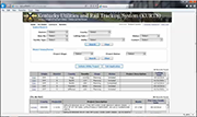
The KURT System walks users through a road project’s utility coordination process including a full utility conflict matrix. This video provides a glimpse into the basic functionality of the Kurt System.
| | | | | |
This video shows live-footage from the SHRP2 R01B Utility Locating Technologies program at Oregon DOT’s project site along SR8, Hocken Avenue and Short Street. It presents the field activities, geophysical instrumentation, vehicle requirements, and staff deployed to acquire multi-channel ground penetrating radar (MCGPR) data. Cardno is the ODOT SUE contractor awarded this project, where Senior staff member Jamie Bradburn narrates the field activities showing acquisition of MCGPR data utilizing the state-of-the-art IDS Stream-EM system.
This video shows Time Domain Electromagnetic Induction (TDEMI) instrumentation used during the SHRP2 R01B Utility Locating Technology program for the Montana DOT’s Custer Avenue project. Shown here are night-time operations of the tow-vehicle and towed-array geophysical instrumentation. This towed configuration of Geonics EM61-MK2A single transmitter and receiver coil systems has three slaved independent transmitter-receiver coils to create a lane-width TDEMI utility mapping array. The towed TDEMI array can travel at speeds of 3 to 5 mph and maintain centimeter GPS data positional accuracy. (Video courtesy of P. Sirles). |
|
|
|
